
The Agri-Drone Revolution: Transforming Irish Farming Practices


Introduction
There was a time when drones were seen as a gimmick, something to capture the silage being drawn home or a good overhead shot of tidy tramlines. But that view is fast changing. Across Ireland, more farmers are realising that these little flying machines can do far more than take nice pictures. They’re saving time, improving safety, and helping farmers make sharper decisions about how they manage their land.
With the cost of inputs climbing and the weather becoming harder to predict, technology that saves both fuel and guesswork is starting to make real sense.
Drones in the Field: Seeing More, Sooner
On Irish farms, drones are quietly becoming the extra pair of eyes that spot what a person on the ground can’t. They’re being used to check grass growth, identify soil and crop stress, and even map problem areas before they spread.
Teagasc trials have shown that drone imagery can detect nitrogen or disease stress in cereal crops two to three weeks earlier than the naked eye. That kind of lead time can mean the difference between saving a crop or losing yield.
For dairy and beef farms, the same technology is being used to measure grass covers. Teagasc-supported work in Cork and Limerick found drone-based measurements to be within 7% of plate meter readings, close enough to be practical. For farmers juggling fragmented land or rented blocks, this kind of accuracy can make grass management far more efficient.

Checking Stock: Safely and Quickly
It’s not just tillage farmers seeing the benefit. Beef and sheep farmers, especially those on hilly or broken ground, are finding drones a real timesaver.
The Health and Safety Authority (HSA) reports that farm vehicle accidents remain the leading cause of deaths and serious injuries on Irish farms, with over 40 ATV-related incidents recorded between 2020 and 2024. A drone can do a job in minutes that might otherwise mean a risky spin across wet ground on a quad.
Farmers in counties like Mayo, Kerry and Galway are using drones fitted with zoom or thermal cameras to check livestock, find missing stock, or monitor calving from a distance. Some say it saves them two to four hours a weekduring the busiest times, and more importantly, reduces the risk of injury.
It’s not about replacing eyes on the ground, it’s about cutting down the unnecessary runs and working a bit smarter.

Spotting Drainage Issues Before They Cost You
If 2025’s start taught us anything, it’s that heavy ground and blocked shores can undo months of good management in a few wet weeks.
Using high-resolution or infrared cameras, drones can pick out wet spots and compaction before they become visible to the eye. Irish contractors offering aerial drainage surveys have found they can identify 15–25% more blockages than manual checks alone.
That kind of insight isn’t just for convenience, it’s saving money. A few blocked drains on silage ground can easily cost a farmer hundreds of euro in lost yield or delayed grazing. Drones are also helping farmers gather data for BISS applications, slurry storage compliance, and buffer-zone mapping, often making inspections a far smoother process.

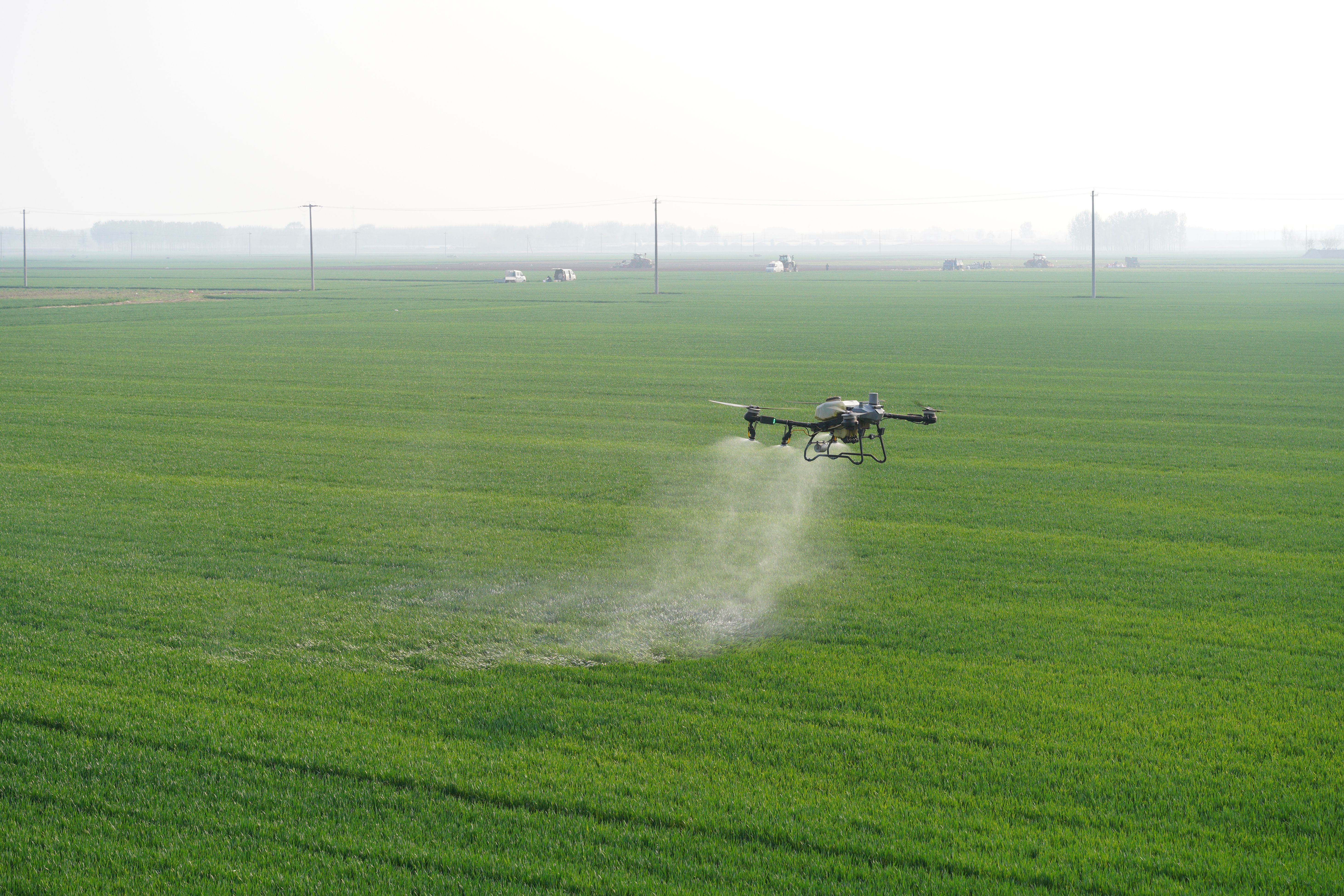
Precision Spraying: Still on the Horizon
Ireland hasn’t yet legalised full drone spraying, but it’s getting closer. The Department of Agriculture and Irish Aviation Authority (IAA) are currently reviewing pilot projects for targeted applications.
Elsewhere in Europe, countries like Spain and France are already using spraying drones to reduce chemical use by 20–30% without losing yield. For Irish conditions, especially soft or fragmented ground, that could be a game-changer.
In the meantime, many farmers are using drones to generate fertiliser “prescription maps,” showing exactly where nutrients are needed. It’s not just better for the pocket, it helps with compliance too, cutting down on unnecessary spreading.
What It Costs: and When It Pays Off
Not every farm will go out and buy a drone straight away, but the numbers are starting to make sense. A solid, GPS-stabilised drone suitable for mapping costs about €1,200–€1,800, while professional agricultural drones with multispectral sensors come in around €5,000–€9,000.
For those who prefer to outsource, hiring a licensed drone operator costs €10–€15 per acre, depending on detail. The savings, especially for larger farms, can repay that in a season or two through reduced inputs and more efficient management.
Under TAMS 3, drones themselves aren’t directly grant-aided, but precision-farming equipment, like GPS spreaders and nutrient-mapping tools, qualify for up to 60% funding. For many, that’s the bridge between wanting to try new tech and being able to afford it.

Rules and Training: Not as Complicated as You Think
If your drone weighs more than 250 grams, it must be registered with the Irish Aviation Authority (IAA). Anyone using one for commercial or professional work, such as spraying or surveying, also needs a qualification and insurance.
The IAA has made the process relatively straightforward, and Teagasc, along with several Irish UAV training centres, now run short certification courses, typically priced between €400 and €700. Once completed, farmers are cleared to operate safely and legally without fear of breaking aviation rules.

The Next Step: From Data to Decisions
Irish researchers are already taking drone use to the next level. Teagasc and UCD projects are exploring how drones can help measure soil carbon levels, biodiversity corridors, and even grass growth rates to support future carbon-credit or eco-scheme payments.
Industry projections suggest that by 2028, around one in three Irish farms will use some form of drone data, whether through contractors, co-ops, or private ownership.
The technology is evolving quickly, but the idea behind it is simple: better information means better decisions.

Conclusion
Drones won’t milk the cows or mend the fence, but they’ll help you make better calls about when and where to act. They can show you where water’s lying, where grass is lagging, or where you’re losing time driving land to check stock.
For Irish farmers, it’s not about shiny gadgets. It’s about staying a step ahead in an industry where margins are tight and weather’s never guaranteed.
In the years ahead, the farms that embrace these small efficiencies will likely be the ones that thrive. Because in modern farming, seeing your land from 200 feet above might just give you the edge you need to manage it better from the ground.
*By Anne Hayden MSc., Founder, The Informed Farmer Consultancy.